

West Coast levee failures show growing risks from America’s aging flood defenses
- Written by Farshid Vahedifard, Professor of Civil and Environmental Engineering, Tufts University
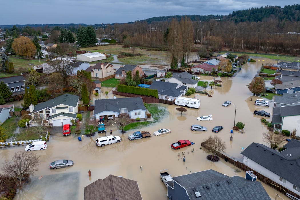 Days of heavy rain caused a levee on the White River to breach, sending water into Pacific, Wash., on Dec. 16, 2025. Brandon Bell/Getty Images
In recent weeks, powerful atmospheric river storms have swept across Washington, Oregon and California, unloading enormous amounts of rain. As rivers surged, they overtopped or breached multiple levees – those long, often unnoticed barriers holding floodwaters back from homes and towns.
Most of the time, levees don’t demand attention. They quietly do their job, year after year. But when storms intensify, levees suddenly matter in a very personal way. They can determine whether a neighborhood stays dry or ends up underwater.
The damage in the West reflects a nationwide problem that has been building for decades. Across the U.S., levees are getting older while weather is getting more extreme. Many of these structures were never designed for the enormous responsibility they now carry.
 Crews inspect damage to a Green River levee in the Seattle suburbs on Dec. 15, 2025. Thousands of people were urged to evacuate during a series of atmospheric river storms, and the National Guard was sent to monitor and reinforce several levees considered at risk.AP Photo/Manuel Valdes
As a civil engineer at Tufts University, I study water infrastructure, including the vulnerability of levees and strategies for making them more resilient. My research also shows that when levees fail, the consequences don’t fall evenly on the population.
Levees became critical infrastructure almost by accident
Many people assume levees were built as part of modern, carefully engineered flood-control systems. In reality, many of the levees still in use today began much more humbly.
Decades ago, farmers built simple earthen embankments to protect their fields and livestock from seasonal flooding. These early levees were practical solutions, shaped by experience rather than formal engineering. They were not constructed using rigorous design standards, and they did not follow consistent construction or maintenance guidelines.
Over time, the landscape around these levees changed. Farmland gave way to neighborhoods. Roads, railways, factories and ports expanded into floodplains. Populations grew. What were once modest, local structures protecting farms gradually became the first line of defense for millions of people in homes and workplaces.
 During the Great Mississippi Flood of 1927, the river poured over and broke through levees, flooding thousands of square miles of land. Both overtopping and a breach are visible in this photo.National Weather Service Archival Photography by Steve Nicklas, NOS, NGS
Without much public debate or planning, these semi-engineered levees took on a critical and unintended role. The question that still lingers is whether they were ever prepared for it.
Vast, aging levee system now protecting millions
Today, the National Levee Database counts more than 24,000 miles (38,600 kilometers) of levees in the U.S., with an average age of about 61 years and many of them much older. Together, they protect over 23 million people, around 7 million buildings and nearly US$2 trillion in property value.
That’s an extraordinary level of responsibility for a system that is unevenly maintained with varying oversight. Some levees are inspected regularly. Others are owned by small local agencies or private entities with limited funding. In some cases, responsibility is unclear or fragmented.
One levee that was breached along the Green River in Washington state during storms in mid-December 2025 had been due for repairs for several years, but disagreements among governments had recently held up needed work, The Seattle Times reported. The breach forced thousands of people to evacuate
 Many states have at-risk levees. The map shows all levees in the U.S. National Levee Database (in red) and 478 levee segments where overtopping is known to have occurred in the previous 15 years (in blue).S. Flynn, et al., 2025
The American Society of Civil Engineers’ 2025 Report Card for American Infrastructure, which I contributed to, gave the nation’s levees a D-plus grade, citing aging infrastructure, inconsistent monitoring and long-term underinvestment. A new dataset that colleagues and I created of levee damage includes 487 cases where rivers poured over levees, known as overtopping, in the past 15 years. That doesn’t mean levees are failing everywhere; it means that many are operating with little margin for error.
How levees fail
Levee failures are rarely sudden collapses. More often, they start quietly.
The most common reason levees fail is overtopping, when water from a river, stream or lake behind the levee flows over the top. Once that happens, erosion can begin on the landward side, weakening the structure from behind. What starts as a slow trickle can quickly grow into a breach, creating a large gap in the levee where water can pour in.
 An illustration shows the difference between overtopping and a breach, and some of the reasons a levee can fail.S. Flynn et al., 2025
Atmospheric river storms make the risk of overtopping and breaches much higher. These storms deliver enormous amounts of rainfall across wide areas in a matter of hours, often combined with snowmelt. Rivers rise faster and stay high longer. Many levees were never designed for that kind of sustained pressure.
When a levee breaches, flooding can be rapid and deep, leaving little time for evacuation and causing damage that spreads far beyond the floodplain.
Who relies on levees today?
Millions of Americans live and work in area protected by levees, often without realizing it. Homes, schools, highways, rail corridors, ports and power facilities depend on the integrity of these structures.
A recent national study found that across the contiguous U.S., urban expansion into floodplains occurred more than twice as fast after levee construction as it did in surrounding counties, highlighting how levees can affect communities’ perception of danger.
In fact, when levees fail, flooding can be worse than in areas without levees, because water rushes in quickly and drains slowly.
The risks are also uneven, shaped by history, economics and policy decisions.
That reality became painfully clear during an atmospheric river storm in March 2023 when a levee along California’s Pajaro River failed, flooding the town of Pajaro. Pajaro is home to many low-income farmworkers. Floodwaters forced hundreds of residents to evacuate, and some people were trapped as water levels rose.
How the Pajaro Valley flooded after intense rainfall from an atmospheric river in March 2023, breaching a levee protecting a small California town.What made the disaster especially troubling was what emerged afterward. Officials and engineers had known for decades that the Pajaro River levee was vulnerable. Reports documented its weaknesses, but repairs were repeatedly delayed.
Interviews by The Los Angeles Times and public records showed that part of the reason was financial. Decision-makers did not prioritize investing in a levee system protecting the low-income community. The risk was known, but the protection was deferred.
Pajaro is not an isolated case. Across the country, disadvantaged communities and communities of color are more likely to rely on older levees or levees that are not part of major federal programs. Rural towns often depend on agricultural levees. Urban neighborhoods may rely on structures built for a much smaller population.
When levees fail, the impacts cascade, closing roads, knocking out power, contaminating water supplies and disrupting lives for years.
 Disparity refers to the percentage of each state’s residents protected by levees who are considered disadvantaged, based on the U.S. Council on Environmental Quality’s Climate and Economic Justice Screening Tool. All levees in the National Levee Database are counted.F. Vahedifard et al., 2023
Why this moment matters
Advances in engineering, monitoring and risk assessment have improved how levees are evaluated and designed.
Hurricane Katrina marked a turning point in 2005 when its storm surge broke through levees protecting New Orleans. Hundreds of people died in the flooding. The disaster exposed the consequences of neglect and fragmented responsibility for levee upkeep.
At the same time, there has been real progress. Over the past two decades, significant federal investments have strengthened the condition and management of many of the nation’s levees, particularly through the work of federal agencies such as the U.S. Army Corps of Engineers.
Still, the legacy of decisions made decades ago remains, and climate change is raising the risks. Heavier rainfall, fast snowmelt and rising seas are pushing water control systems beyond what many levees were designed to handle. Events once considered rare are becoming more frequent.
As atmospheric rivers test levees in the West and flood risks grow nationwide, the challenge is no longer just technical. It’s about how society values protection, communicates risk and decides whose safety is prioritized.
Levees will continue to play a vital role in protecting communities. Understanding their history, and their limits, is essential as the storms of the future arrive.
Farshid Vahedifard received funding from the National Science Foundation (NSF) and the National Oceanic and Atmospheric Administration (NOAA). He is affiliated with the United Nations University Institute for Water, Environment and Health (UNU-INWEH).
Authors: Farshid Vahedifard, Professor of Civil and Environmental Engineering, Tufts University